The Gay Courier has been established to provide news, information and info on, from and about the gay community, and other social events and happenings from around the world, from all sorts of sources, to all who are interested in this news, information and info!
The postings are as is, and all copyrights and or ownerships are and remain with the original copyright-holder and or owner!
Search This Blog
Sunday, June 12, 2016
Revealed: Cambodia's vast medieval cities hidden beneath the jungle
Revealed: Cambodia's vast medieval cities hidden beneath the jungle
Exclusive: Laser technology reveals cities concealed under the earth which would have made up the world’s largest empire in 12th century
Archaeologists in Cambodia
have found multiple, previously undocumented medieval cities not far
from the ancient temple city of Angkor Wat, the Guardian can reveal, in
groundbreaking discoveries that promise to upend key assumptions about
south-east Asia’s history.
The Australian archaeologist Dr Damian Evans, whose findings will be
published in the Journal of Archaeological Science on Monday, will
announce that cutting-edge airborne laser scanning technology has
revealed multiple cities between 900 and 1,400 years old beneath the
tropical forest floor, some of which rival the size of Cambodia’s
capital, Phnom Penh.
Some experts believe that the recently analysed data – captured in
2015 during the most extensive airborne study ever undertaken by an
archaeological project, covering 734 sq miles (1,901 sq km) – shows that
the colossal, densely populated cities would have constituted the
largest empire on earth at the time of its peak in the 12th century.
Evans said: “We have entire cities discovered beneath the forest that
no one knew were there – at Preah Khan of Kompong Svay and, it turns
out, we uncovered only a part of Mahendraparvata on Phnom Kulen [in the
2012 survey] … this time we got the whole deal and it’s big, the size of
Phnom Penh big.”
A research fellow at Siem Reap’s École Française d’Extrême-Orient (EFEO) and the architect of the Cambodian Archaeological Lidar Initiative (Cali), Evans will speak at the Royal Geographic Society in London about the findings on Monday.
Evans obtained European Research Council (ERC) funding for the
project, based on the success of his first lidar (light detection and
ranging) survey in Cambodia in 2012. That uncovered a complex urban
landscape connecting medieval temple-cities, such as Beng Mealea and Koh
Ker, to Angkor, and confirmed what archaeologists had long suspected,
that there was a city beneath Mount Kulen. It was not until the results
of the significantly larger 2015 survey were analysed that the size of
the city was apparent.
That survey uncovered an array of discoveries, including elaborate
water systems that were built hundreds of years before historians
believed the technology existed. The findings are expected to challenge
theories on how the Khmer empire developed, dominated the region, and
declined around the 15th century, and the role of climate change and
water management in that process.
“Our coverage of the post-Angkorian capitals also provides some
fascinating new insights on the ‘collapse’ of Angkor,” Evans said.
“There’s an idea that somehow the Thais invaded and everyone fled down
south – that didn’t happen, there are no cities [revealed by the aerial
survey] that they fled to. It calls into question the whole notion of an
Angkorian collapse.”
The Angkor temple ruins, which sprawl across the Unesco-protected
Angkor archaeological park, are the country’s top tourist destination,
with the main temple-city, Angkor Wat, appearing on the Cambodian
national flag. Considered the most extensive urban settlement of
pre-industrial times, and boasting a highly sophisticated water
management system, Angkor’s supposed decline has long occupied
archaeologists.
The new cities were found by firing lasers to the ground from a
helicopter to produce extremely detailed imagery of the Earth’s surface.
Evans said the airborne laser scanners had also identified large
numbers of mysterious geometric patterns formed from earthen
embankments, which could have been gardens.
Experts in the archaeological world agree these are the most significant archaeological discoveries in recent years.
Michael Coe, emeritus professor of anthropology at Yale University
and one of the world’s pre-eminent archaeologists, specialises in Angkor
and the Khmer civilisation.
“I think that these airborne laser discoveries mark the greatest
advance in the past 50 or even 100 years of our knowledge of Angkorian
civilisation,” he said from Long Island in the US.
There is an undiscovered city beneath Mount Kulen. Photograph: Terence Carter
“I saw Angkor for the first time in 1954, when I wondered at the
magnificent temples, but there was nothing to tell us who had lived in
the city, where they had lived, and how such an amazing culture was
supported. To a visitor, Angkor was nothing but temples and rice
paddies.”
Charles Higham, research professor at the University of Otago in
Dunedin, New Zealand, and the leading archaeologist of mainland
south-east Asia, said it was the most exciting paper he could recall
reading.
“I have been to all the sites described and at a stroke, they spring
into life … it is as if a bright light has been switched on to
illuminate the previous dark veil that covered these great sites,”
Higham said. “Personally, it is wonderful to be alive as these new
discoveries are being made. Emotionally, I am stunned. Intellectually, I
am stimulated.”
David Chandler, emeritus professor at Monash University in Melbourne,
Australia, the foremost expert on Cambodian history and the author of
several books and articles on the subject, said the work was thrilling
and credited Evans and his colleagues with “rewriting history”.
Chandler said he believed it would open up a series of perspectives
that would help people know more about Angkorian civilisation, and how
it flourished and eventually collapsed.
“It will take time for their game-changing findings to drift into
guide books, tour guides, and published histories,” Chandler said. “But
their success at putting hundreds of nameless, ordinary, Khmer-speaking
people back into Cambodia’s past is a giant step for anyone trying to
deal with Cambodian history.”
David Kyle, an archaeologist and ecological anthropologist has
conducted projects at Phnom Kulen, the location of the biggest findings,
the massive city of Mahendraparvata, the size of Phnom Penh, beneath
the forest floor.
He said the “survey results have revolutionised our understanding and
approaches. It’s impossible not to be excited. It facilitates a
paradigm shift in our comprehension of the complexity, size and the
questions we can address.”
While the 2012 survey identified a sprawling, highly urbanised
landscape at Greater Angkor, including rather “spectacularly” in the
“downtown” area of the temple-city of Angkor Wat, the 2015 project has
revealed a similar pattern of equally intense urbanism at remote
archaeological ruins, including pre- and post-Angkorian sites.
Dr Peter Sharrock, who is on the south-east Asian board at London
University’s School of Oriental and African Studies and has a
decades-long connection to Cambodia, said the findings showed “clear
data for the first time of dense populations settled in and around all
ancient Khmer temples”.
“This urban and rural landscape, linked by road and canal networks,
now seems to have constituted the largest empire on earth in the 12th
century,” Sharrock said.
Evans, whose domain is an air-conditioned room full of computers at
the French archaeological centre in Siem Reap, rather than dirt trenches
at far-flung digs, is modest about his achievements and quick to credit
his colleagues on the Cali project.
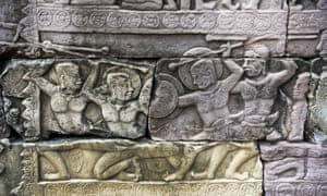
A fight scene depicted in detail in the bas-reliefs at the Banteay Chhmar temple complex. Photograph: Terence Carter
He said he believed the discoveries would completely upend many
assumptions about the Khmer empire. He also hoped it would bring the
study of people back into the picture.
Coe, who has been to many of the places covered by the survey and
has seen the imagery, said that while the 2012 survey of Phnom Kulen
demonstrated what the technology could do – “it could look through the
dense jungle covering these hills and reveal an unexpected city which
predated Angkor itself” – the 2015 survey took this into new dimensions.
This view was shared by Dr Mitch Hendrickson, the director of the
industries of Angkor project and assistant professor in the department
of anthropology at the University of Illinois. He said the initial
survey had been “an incredible leap forward” in archaeologists’ ability
to see everything for the first time and had been “a major game-changer”
in understanding how the Angkorian Khmer people built, modified and
lived in their cities. But he was “stunned” by the second survey.
“The results for Preah Khan of Kompong Svay are truly remarkable and
are arguably the jewel in the crown of this mission. The lidar shows us
that there was much, much more,” Hendrickson said, referencing a
full-blown community layout that was previously unknown. “It’s both
humbling and exciting. There are so many fantastic new discoveries.”
“We knew that Preah Khan of Kompong Svay was significant before the
lidar – it’s the largest complex ever built during the Angkorian period
at 22 sq km, it is connected to Angkor directly by a major road fitted
with infrastructure, and likely played a role in facilitating iron
supply to the capital.
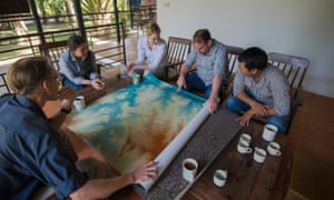
The team at Siem Reap’s École Française d’Extrême-Orient look at a map of the site. Photograph: Terence Carter
“The new results suggest that it may have been more important than
many temples built in Angkor and that it had a decent-sized population
supporting it.”
Dr Martin Polkinghorne, a research fellow in the department of
archaeology at Adelaide’s Flinders University who is conducting a joint
research project on Longvek and Oudong, the post-Angkorian capitals,
said his team would use the data during excavations scheduled until 2019
to understand the cities.
“The decline of Angkor is among the most significant events in the
history of south-east Asia, but we do not have a precise date for the
event,” Polkinghorne said. “By using lidar to guide excavations on the
capitals of Cambodia that followed we can determine when the kings of
Angkor moved south and clarify the end of Angkor.
“Cambodia after Angkor is customarily understood in terms of loss,
retreat and absence; a dark age,” he said. “Yet, Cambodia was alive with
activity after Angkor. South-east Asia was the hub of international
trade between east and west. Using the lidar at Longvek and Oudong in
combination with conventional archaeology we will reveal the dark age as
equally rich, complex and diverse.”
What is a lidar survey?
An airborne laser scanner (ALS) is mounted to a helicopter skid pad.
Flying with pre-determined guidelines, including altitude, flight path
and airspeed, the ALS pulses the terrain with more than 16 laser beams
per square metre during flights. The time the laser pulse takes to
return to the sensor determines the elevation of each individual data
point.
The data downloaded from the ALS is calibrated and creates a 3D model
of the information captured during the flights. In order to negate tree
foliage and manmade obstacles from the data, any sudden and radical
changes in ground height are mapped out, with technicians who have
models of the terrain fine-tuning the thresholds in processing these
data points. Once completed, the final 3D model is handed over to the
archaeologists for analysis, which can take months to process into maps.


No comments:
Post a Comment